News

Another stage of the project is completed

News

On June 15, 2018, the meeting of the commission from Committee on Communications and IT of the Leningrad region was held at Regional navigation information center in order to evaluate the results of the 3rd working period of the project “Development of the Leningrad Region Spatial Data Fund”.

LITSAM senior researcher, Candidate of Technical Sciences Semyon Potriasaev and junior researcher Ilya Pimanov took part in the meeting and successfully demonstrated the obtained results.

LITSAM presented the developed web application for georeferencing the objects of the terrain and the improved module for calculating and building connection between spatial objects in spatial data fund (SDF).

As a result of the meeting the commission decided to continue the work on developing Leningrad Region Spatial Data Fund.

Testing of the operative flood forecasting system

News

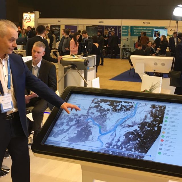
Operational river flood monitoring and forecasting system «Prostor» created under the Russian Science Foundation grant 17-11-01254 is currently being tested on the part of Northern Dvina river – from the city of Velikiy Ustyug to the city of Kotlas.

The principal key feature of the “Prostor” system is full automation of all stages of operation, including:

  • loading of data from hydroposts (automated hydrological complexes) and meteorological data;
  • generation of the contours and depths of flooding;
  • publication of created contours on the GIS platform;
  • identification of objects inside the flooded area;
  • notification of interested persons.

Automation of processes and friendly simplified interface provides easy intuitive operation with the system even if the user is not a specialist in the field of hydrology, data processing, information and GIS technologies.

Every hour the system forms 24-hour forecast of flooded areas and depths for 24-48 hours ahead in the operational mode. The following operation scenario is also available: what happens if water levels at hydroposts reach the particular value.

The images from Russian satellite Resurs-P, European satellites Sentinel-1 and Sentinel-2 are constantly being loaded into the system – processed and published images give the opportunity to assess the accuracy of the modeling and quickly refine the parameters of models.

The potential users of the system are local administrations, regional hydrometeorological services, emergency services, services for population protection. Currently, they evaluate the test version of the system.

The system “Prostor” is focused, first of all, on the regional level of use where a highly detailed analysis of the available source data (such as digital elevation models, riverbed characteristics, permanent and temporary data from hydroposts, information about specific infrastructure in potentially flooded areas etc.) is necessary and requirements to the accuracy of simulation results used in the planning of protective and rescue measures are particularly high.

To work on the project, a team of specialists has been formed, combining advanced Russian scientific schools of both hydrological / hydrodynamic modeling and automatiс modeling, integrating heterogeneous information resources and creating modern information systems and services. This determines the uniqueness of the system and its truly interdisciplinary nature which has no analogues in Russia in this field of projects implementation.

At the previous stages of the research a successful testing of the system based on historical data was carried out. Currently, the most complex mechanisms for responding to hydrological phenomena (primarily associated with ice jams) are being worked out in operational mode.

The system and its preliminary test results were presented at the St. Petersburg Digital Forum and aroused great interest of specialists.

The “Prostor” system is a completely Russian technology based on open source software. The following Russian software systems are applied for the system operation: «STREAM 2D» (Certificate of software registration № 2014612181), «ECOMAG» (Certificate of software registration № 2013610703) and also the systems developed at LITSAM – «UnisonPro» (Certificate of software registration № 2016660672) and «RegionView» (Certificate of software registration № 2016612635).

No Images found.

Best Paper Award

News

In the framework of 55th anniversary celebration International Journal of Production Research selected 15 best papers from papers published in 2016 and 2017.

The head of LITSAM Professor Sokolov B.V. obtained the IJPR Best Paper Award for the following paper:

“A dynamic model and an algorithm for short-term supply chain scheduling in the smart factory industry 4.0” (Authors: Dmitry Ivanov, Alexandre Dolgui, Boris Sokolov, Frank Werner & Marina Ivanova).

The access to the best papers will be free during the 2018 via the IJPR website.

InMotion in Malaysia

News

On April 16-18, 2018, the work meeting on ERASMUS+ InMotion project was held at Malaysian University of Technology (UTM).

The representatives of all project partners took part in the event. At the meeting the participants discussed the main results of the 3rd working period and prepared the work plan for the next period.

During the discussion of the teaching and learning materials developed by the projects participants LITSAM representatives made a report on the results of the SPIIRAS activities on reviewing of syllabi, textbooks and guidelines created by partner universities and recommendations of stakeholders on improving these materials.

BalticSatApps in Stockholm

News

On April 12-13, 2018, the work meeting on BalticSatApps project (program Interreg Baltic Sea Region) was held in Stockholm. The project is aimed at expanding the application of remote sensing data provided by the European Copernicus program.

The representatives of the following organizations took part in the event: Finnish Meteorological Institute, University of Turku, Turku Science Park, Aalto University (Finland), Swedish National Space Board (Sweden), Cracow University of Technology, Krakow Technology Park (Poland), Institute of Geodesy and Cartography (Warsaw, Poland), University of Tartu (Estonia).

The main purpose of the conference was to discuss the results of the 1st working period of the project. Besides, the official representative of the Copernicus support office provided trainings on the newest Copernicus opportunities.

Executive Director of the Russian-European InnoPartnership Maria Kuzko made a report on the results of the project implementation by Russian partners.

Representatives of the SPIIRAS presented proposals on the development of an information analytical system for creating and providing thematic services using remote sensing data.

Symbolically, the first day of the event – April 12 – was the Cosmonautics Day. Russian partners reminded about this and congratulated European colleagues.

14th Big Geographical Festival

News

On April 06-08, 2018 the 14th Big Geographical Festival took place at the Institute of Earth Sciences of St. Petersburg University.

BGF-2018 was dedicated to the 100th Anniversary of the creation of the 1st special geographic higher educational institution in Russia – the Geographical Institute.

Within the framework of the festival on April 07, 2018 the International scientific and practical conference of students, postgraduate students and young scientists was held.

One of the main and most visited sections of the conference is annually “Cartography and geodesy, GIS-technologies in geographical research, land management and cadastres”.

On the section «Remote sensing» (expert of this section was the head of the Department of Cartography and Geoinformatics, PhD Panidi Evgeny Alexandrovich) LITSAM junior researcher Ilya Pimanov presented a report on the following topic:

Use of space radar sensing data for verification of results of short-term forecasting of high water flood (Authors: Pimanov I.Yu., Ponomarenko M.R. ).

Mapping Water Bodies from Space 2nd Conference (MWBS-2018)

News

On 27-28 March, 2018 the 2nd International Conference «Mapping Water Bodies from Space (MWBS-2018)» took place in Frascati, Italy.

The conference is organized by the European Space Agency (ESA) and held at ESA-ESRIN (ESA Centre for Earth Observation). MWBS gives an opportunity for specialists in Earth remote sensing data to present their current research on the topic of using satellite data for identification and mapping of water bodies and inundated areas.

At MWBS-2018 junior researcher of LITSAM Ilya Pimanov presented the following report:

“SAR Based Mapping of Flooded Areas for the Validation of Short-term Flood Forecasting” (Authors: Ponomarenko Maria, Pimanov Ilya).

The presented research attracted the interest of the colleagues.

Project «Technology-US» continues

News

LITSAM won the tender to continue the work on project «Technology-US» under the Union State of Russia and Belarus program.

The project customer is Space Systems Research and Development Institute (NII KS). The work on the project will last until 2020.

The research is aimed at development of technology for managing the configuration (reconfiguration) of small-size spacecraft on-board equipment in order to improve their survivability, in particular, to ensure their resistance to radiation effects.

New grants of Russian Foundation for basic research

News

At the end of 2017 – beginning of 2018 the Russian Foundation for basic research (RFBR) summed up the call for proposals. As a result, LITSAM won grants for the following projects:

  • Development of theoretical and technological foundations of intelligent decision support in the area of integrated urban arterial transportation planning in metropolitan areas taking into account preferences of passengers of various social groups (Project head – Sokolov B.V.);
  • Development and research of methods and algorithms of pro-active control of maintenance of onboard systems of complex dynamic objects at emergency situations (Project head – Ohtilev M.Yu.).